NIRCC
  • Home
  • Planning
    • Bicycle & Pedestrian >
      • Bicycle & Pedestrian
      • Poka-Bache Connector >
        • Steuben County Poka-Bache
        • DeKalb County Poka-Bache
        • Allen County Poka-Bache
        • Wells County Poka-Bache
      • Horse Trails
    • Community Development >
      • ADA
      • Environment >
        • Air Quality
        • Red Flag
        • Water Quality
      • Grant Resources
      • Park Planning
      • Title VI
      • Water Trails
    • Highway >
      • ADA
      • Air Quality
      • Congestion Management Program
      • Corridor Analyses
      • Red Flag
      • Rural Plans
      • Safety
      • Title VI
      • Traffic Data >
        • Traffic counts
        • Traffic data request
        • Intersection/Arterial Data
        • Travel Time Studies
      • Traffic Incident Management
      • Transportation Improvement Program >
        • TIP Amendments for public comment
        • Approved Amendments & Administrative Modifications
      • Transportation Plans
    • Maps
    • Transit
  • Documents
  • Get Involved
    • Nircc mpo certification review
    • Calendar
    • Request for Proposals
    • Current Funding Opportunities
    • Documents for Public Comment
    • General Comment
    • Newsletter
    • Participation Plan
    • Receive Notices
    • TIP Amendments for public comment
    • UTAB
  • Info
    • About >
      • IARC
      • IMPO
    • Calendar
    • Contact >
      • Directions
    • Newsletter
    • Our Staff
    • Things of Interest
    • Transportation Summary Report
    • Useful Links
  • Search
Poka-Bache Connector
United Trails Poka-Bache connector logo
The Poka-Bache Connector is an 81-mile long State Visionary Trail connecting Pokagon State Park near Angola with Ouabache (pronounced Wabash) State Park near Bluffton. The trail will travel through 4 counties and 7 cities and towns. The trail will connect over 121,000 people, 140 recreational areas, 10 Libraries and 50 schools within 1 mile of the trail.

See Maps and Economic Impact Study files below...
Back to Main Page

Maps:
  • Poka-Bache Connector - Ouabache State Park to Pokagon State Park (size 36 x 50 inches)
  • Poka-Bache Community Map (size 36 x 50 inches)

    Poka-Bache Concept Maps:
  • Poka-Bache Concept (size 36 x 80 inches)
  • Poka-Bache Concept (size 36 x 50 inches)
  • Poka-Bache Concept (size 8.5 x 11 inches)

Economic Impact Study:
  • PFW Poka-Bache Economic Impact Report - FINAL 10-24-22
  • PFW Poka-Bache Economic Impact Report - Executive Summary and Introduction
  • Chart 1 - Total jobs supported by construction of trails 2008-2022
  • Chart 3 - Total economic impact of construction of trails 2008-2022
  • Chart 9 - Total jobs supported by future trails 2023-2045
  • Chart 11 - Total economic impact of future trails 2023-2045
  • Chart 17 - Total jobs supported annually from visitor and retail spend 2022
  • Chart 19 - Total economic impact annually from visitor and retail spend 2022

Poka-Bache Connector by Jurisdiction (from Pokagon State Park to Ouabache State Park)
The following links each have a dedicated page that is unique to each area the Poka-Bache Connector trail traverses. These pages will provide you with current projects, special links, maps and other information unique to each city, town, or county.
  • Steuben County (Angola)
  • DeKalb County (Waterloo and Auburn)
  • Allen County (Huntertown and Fort Wayne)
  • Wells County (Ossian and Bluffton)
Picture of Poka-Bache Connector map
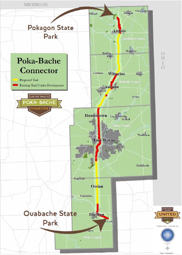
Poka-bache connector trail map
Back to Main Page
United Trails Poka-Bache Connector
United Trails Poka-Bache connector logo small
NIRCC Northern indiana regional coordinating council logo
Vertical Divider
NIRCC
About
Contact
Our Staff
Calendar
Newsletter

​Useful Links
Vertical Divider
Quick Links
ADA
Title VI
​Transportation Improvement Prog
Transportation Plan
Traffic Data
Vertical Divider
Planning
Bicycle and Pedestrian
Community Development
Highway
Maps

Transit
  • Home
  • Planning
    • Bicycle & Pedestrian >
      • Bicycle & Pedestrian
      • Poka-Bache Connector >
        • Steuben County Poka-Bache
        • DeKalb County Poka-Bache
        • Allen County Poka-Bache
        • Wells County Poka-Bache
      • Horse Trails
    • Community Development >
      • ADA
      • Environment >
        • Air Quality
        • Red Flag
        • Water Quality
      • Grant Resources
      • Park Planning
      • Title VI
      • Water Trails
    • Highway >
      • ADA
      • Air Quality
      • Congestion Management Program
      • Corridor Analyses
      • Red Flag
      • Rural Plans
      • Safety
      • Title VI
      • Traffic Data >
        • Traffic counts
        • Traffic data request
        • Intersection/Arterial Data
        • Travel Time Studies
      • Traffic Incident Management
      • Transportation Improvement Program >
        • TIP Amendments for public comment
        • Approved Amendments & Administrative Modifications
      • Transportation Plans
    • Maps
    • Transit
  • Documents
  • Get Involved
    • Nircc mpo certification review
    • Calendar
    • Request for Proposals
    • Current Funding Opportunities
    • Documents for Public Comment
    • General Comment
    • Newsletter
    • Participation Plan
    • Receive Notices
    • TIP Amendments for public comment
    • UTAB
  • Info
    • About >
      • IARC
      • IMPO
    • Calendar
    • Contact >
      • Directions
    • Newsletter
    • Our Staff
    • Things of Interest
    • Transportation Summary Report
    • Useful Links
  • Search