BICYCLE & PEDESTRIAN
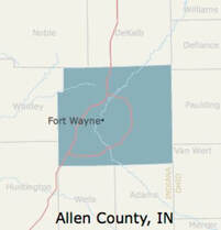
NIRCC conducts bicycle and pedestrian planning activities in Allen County and throughout Northeast Indiana. NIRCC produced the Northeast Indiana United Trails Plan, which identifies trail plans throughout Northeast Indiana (includes 12 Counties), and the Bicycle-Pedestrian Transportation Plan, which includes bicycle and pedestrian infrastructure plans for Allen County and the Northeast Indiana Region (i.e. on-street bike facilities, trails, and sidewalks). While areas outside Allen County may only identify trail plans and various on-street bicycle facility plans, areas within Allen County have detailed plans including on-street facility needs, trail plans, and sidewalk needs. (More Description)
|
|
click below for:
Information and Maps regarding the Poka-Bache Connector |
Northeast Indiana United Trails Brand & Wayfinding Signage Guidelines
Other Bicycle/Pedestrian Planning Documents:
Allen County Equestrian Course (Horse Trails)


MORE DESCRIPTIONS
MAIN
The region represented by NIRCC has many individuals and organizations advocating improvements to the existing bicycle-pedestrian transportation system. To coordinate these efforts and develop a bicycle and pedestrian plan NIRCC sponsored the Northeastern Indiana Regional Bicycle and Pedestrian Forum in 2002. The Forum represented a task force comprised of governmental park departments, planning and highway agencies, advocacy groups, and special project organizations. The overall goal of the Forum was to develop a bicycle-pedestrian transportation plan for the region. The concept was to develop a planning tool for planners and highway officials by identifying a set of routes based on an analysis of significant destinations within the region. Once this was accomplished, the routes were recommended for enhancement and protection.
These routes were assigned design classifications based on the proposed “Allen County Road Specifications and Standards 2004 manual” and the “1999 AASHTO guide for the development of bicycle facilities” to give planners and highway officials standards to follow as they coordinated them with road projects and developments. NIRCC uses the most current AASHTO guide for design classifications used on the current Bicycle-Pedestrian Transportation Plan. These design classifications include bike lanes, widened outside curb lanes, shoulder lanes, sharrows, and bike routes for the on-street network. The off-street network includes trails and sidewalks.
The initial version of the Bicycle-Pedestrian Transportation Plan was adopted in Fiscal Year 2005. Since then NIRCC has continued to update and improve the plan as needed. In 2007 NIRCC incorporated the “Regional Bicycle and Pedestrian Plan for Northeast Indiana”. This regional plan was rebranded in 2017 as the “Northeast Indiana United Trails System”. Through the years recommendations incorporated into the plan included the needs expressed through public input and local advocacy groups such as Aboite New Trails, Greenway Consortium, Little River Wetlands, Northwest Allen Trails, and Fort Wayne Trails Inc. Other plans and recommendations from Allen County, Fort Wayne, New Haven, Leo-Cedarville, Grabill, Woodburn, and Monroeville have provided input or have been included in the plan as well.
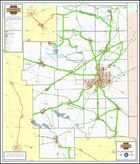
The Bicycle-Pedestrian Transportation Plan for Allen County has separated out the bicycle and pedestrian plan elements into three separate maps. Since there can be multiple needs for a corridor all three maps need to be used.
The region represented by NIRCC has many individuals and organizations advocating improvements to the existing bicycle-pedestrian transportation system. To coordinate these efforts and develop a bicycle and pedestrian plan NIRCC sponsored the Northeastern Indiana Regional Bicycle and Pedestrian Forum in 2002. The Forum represented a task force comprised of governmental park departments, planning and highway agencies, advocacy groups, and special project organizations. The overall goal of the Forum was to develop a bicycle-pedestrian transportation plan for the region. The concept was to develop a planning tool for planners and highway officials by identifying a set of routes based on an analysis of significant destinations within the region. Once this was accomplished, the routes were recommended for enhancement and protection.
These routes were assigned design classifications based on the proposed “Allen County Road Specifications and Standards 2004 manual” and the “1999 AASHTO guide for the development of bicycle facilities” to give planners and highway officials standards to follow as they coordinated them with road projects and developments. NIRCC uses the most current AASHTO guide for design classifications used on the current Bicycle-Pedestrian Transportation Plan. These design classifications include bike lanes, widened outside curb lanes, shoulder lanes, sharrows, and bike routes for the on-street network. The off-street network includes trails and sidewalks.
The initial version of the Bicycle-Pedestrian Transportation Plan was adopted in Fiscal Year 2005. Since then NIRCC has continued to update and improve the plan as needed. In 2007 NIRCC incorporated the “Regional Bicycle and Pedestrian Plan for Northeast Indiana”. This regional plan was rebranded in 2017 as the “Northeast Indiana United Trails System”. Through the years recommendations incorporated into the plan included the needs expressed through public input and local advocacy groups such as Aboite New Trails, Greenway Consortium, Little River Wetlands, Northwest Allen Trails, and Fort Wayne Trails Inc. Other plans and recommendations from Allen County, Fort Wayne, New Haven, Leo-Cedarville, Grabill, Woodburn, and Monroeville have provided input or have been included in the plan as well.
The Bicycle-Pedestrian Transportation Plan for Allen County has separated out the bicycle and pedestrian plan elements into three separate maps. Since there can be multiple needs for a corridor all three maps need to be used.
The Sidewalk Plan
This Plan identifies sidewalk needs along all major roadways in the urban area and some outside the urban area. This map displays all existing sidewalks and trails within Allen County and specifically identifies corridors or sections of roadways that need sidewalks on one side or both sides depending on existing features and proposed trails that parallel. The sidewalk needs identified on the map will be used to prioritize sidewalk improvements and identify the need for sidewalks as development spreads throughout the urban area. The map also includes a green shaded area that refers to the sidewalk and bicycle parking recommendations policy included in the 2035 Transportation Plan. Other than what is specifically identified on the map, these areas should always consider sidewalks and bicycle parking amenities as needed depending on development patterns and opportunities that arise.
This Plan identifies sidewalk needs along all major roadways in the urban area and some outside the urban area. This map displays all existing sidewalks and trails within Allen County and specifically identifies corridors or sections of roadways that need sidewalks on one side or both sides depending on existing features and proposed trails that parallel. The sidewalk needs identified on the map will be used to prioritize sidewalk improvements and identify the need for sidewalks as development spreads throughout the urban area. The map also includes a green shaded area that refers to the sidewalk and bicycle parking recommendations policy included in the 2035 Transportation Plan. Other than what is specifically identified on the map, these areas should always consider sidewalks and bicycle parking amenities as needed depending on development patterns and opportunities that arise.
The Trails Plan
This Plan shows the entire existing trail system for Allen County as well as how it will tie in with what is planned to occur over the next several years and into the future. The trails identified as “Planned” are facilities that are being built along with road projects or are standalone projects that have all or most of their funding and we are confident they will be constructed in the near future. The trails identified as “Proposed” vary in their stages of development. These trails may be very conceptual or may currently be in some stage of development but lack the funds to really push them forward to construction. The trails plan for Allen County is also part of the Northeast Indiana United Trails system which encompasses 12 counties in Northeast Indiana.
This Plan shows the entire existing trail system for Allen County as well as how it will tie in with what is planned to occur over the next several years and into the future. The trails identified as “Planned” are facilities that are being built along with road projects or are standalone projects that have all or most of their funding and we are confident they will be constructed in the near future. The trails identified as “Proposed” vary in their stages of development. These trails may be very conceptual or may currently be in some stage of development but lack the funds to really push them forward to construction. The trails plan for Allen County is also part of the Northeast Indiana United Trails system which encompasses 12 counties in Northeast Indiana.
The Bike and Trail Plan
This Plan is really intended to show an overall bike network along with the trails plan. Since bicyclists use a combination of on-street infrastructure and trails this map includes both to show how the entire network works together. This map displays a wide range of proposed and existing infrastructure for bicycling. The proposed and existing facilities displayed include bike lanes, widened outside curb lanes, shoulder lanes, sharrows, bike routes, and trails.
This Plan is really intended to show an overall bike network along with the trails plan. Since bicyclists use a combination of on-street infrastructure and trails this map includes both to show how the entire network works together. This map displays a wide range of proposed and existing infrastructure for bicycling. The proposed and existing facilities displayed include bike lanes, widened outside curb lanes, shoulder lanes, sharrows, bike routes, and trails.